
‘Revealing Dalieh’
Alternative visions along Beirut’s coast.
A proposal for the conservation and future development of Dalieh - in collaboration with Antoine Atallah
Disappearing geographical markers
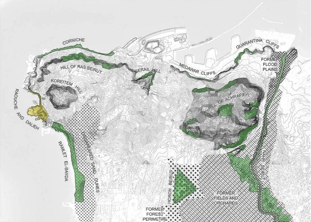
Beirut was founded on the Mediterranean Sea, between beaches and cliffs, and on two hills surrounded by a river, pine forests, sand dunes and agricultural fields. Though the lifestyle, building typologies and urban fabric of Beirut were for long defined by that strong geography, the intensive post-independence urbanization rapidly transformed, reshaped and concealed the city’s natural landscape. The river’s ample undulations were straightened and channeled in a concrete canal. The sand dunes disappeared as well as most agricultural fields, whereas the pine forest dramatically shrunk. The hills of Achrafieh and Ras Beirut are not discernible anymore, under an increasingly high and haphazard skyline. The coast was either filled in by port activities, covered by the wide avenues that circle Beirut, or privatized by beach resorts.
With the disappearance of the city’s geographical markers, the practices that revolved around them also disappeared.

The Dalieh Peninsula is one of the last places in Beirut where both landscape and social practices are preserved.
It is a place where the coast has a thickness, where a space exists between the water edge and the sidewalk of the Corniche.
‘Revealing Dalieh’ proposes to maintain and sustain that human and natural landscape. It will also make it accessible and desirable for a greater number of Beirut citizens who crave for a stronger proximity to their natural environment.
Being in touch with the city’s primal geography anchors a sense of belonging that urgently needs to be developed in Beirut.
The project preserves Dalieh as a coastal threshold, a unique space between the city and the sea free and open to the appropriation of the people.

Contrary to the urban policies of the previous decades, whereas geography was transformed to serve human needs, the project is generated by the topography, the shoreline, the coastal vegetation – and the practices that they carry.
Dalieh is envisioned as a platform where this experience of a coastal threshold can be lived intensely, through sports, activities, and learning or just through the simple act of contemplation.


The area north of Dalieh will remain a place of public gatherings and site-seeing, taking advantage of the proximity of the iconic Raoucheh rocks. On its edges, one building will host exhibitions and events while another one will house a nature sports center, as the Peninsula is a perfect terrain to practice diving, cliff-climbing, speleology and boating. Open air movies will be watched from the amphitheatre-like slopes of the “summit” and fishermen’s cabins will also be brought back after being demolished in May 2015.
South of Dalieh, the Fishermen’s Port will be given the possibility to expand as fishing has become an activity increasingly pushed out of Beirut’s coast. It will expand with new quays, dry docks and boat workshops, but also a fish market and restaurant. The coves, beaches and sheltered natural pools of Shat Falasteen are ideal for children to swim in more protected waters and will form a family area, together with the fishermen’s restaurant, a café and beach services.
In between north and south, will be a vast area of Natural Conservation and Vegetation Restoration, an area to simply observe and take pleasure in the natural landscape, spanning from the hillside vegetation to the marine terraces. The marine terraces remain a space free for all kinds of appropriation, whereas the areas of fragile vegetation will allow a more limited set of activities.
In the middle, the Centre for Coastal Geography will include a cultural program of exhibitions, workshops and conferences dedicated to the Lebanese Coast, a municipal library and will be the administrative body managing the Dalieh Peninsula. In order to make these cultural programs closest to the public, they are placed directly adjacent and accessible from the Corniche, yet mostly built below the level of the sidewalk in order to preserve the views onto the Peninsula and the Sea.
The placement of buildings, the drawing of paths and accesses respond to the need to protect, reinforce and develop Dalieh’s natural habitats. About 95% of building footprints are located on soils that were damaged by human activities, concrete blocks, former constructions or existing paths. In order to limit the “artificialisation” of the ground, the leveled floor of former buildings are either reused in new buildings or become new flat terraces. Some of the concrete blocks are kept in-situ and house an exhibition and event space under their odd geometric spaces, whereas some other blocks are used to shelter the fishermen’s port with one or two new jetties.
Circulation within the existing green areas will be limited to designated itineraries in order to protect the vegetation from repeated and haphazard treading. Walking through the areas of vegetation conservation will only be possible through a limited number of paths built on elevated platforms, which will protect the vegetation from repeated treading. A few other paths that exist today and which caused degradation to the vegetation will be cancelled.
Where natural habitats were lost, vegetation will be brought back in a set of large patches, in a triangulated pattern that abstracts the topography. Some of the patches will carry vegetation identical to Dalieh’s local flora and should be of limited access. However some will also be dedicated to picnics and outdoor leisure in an attempt to relocate the gatherings currently happening on fragile vegetation and will be planted with plant species more resistant to trampling.


Buildings emerge from the geography, their shapes and volumes are generated by the directing lines and features of the terrain, by the topography and shoreline. Always half buried under the ground and revealed progressively with the descending topography, they are expressed as single slabs cascading down the slopes and hills of the Peninsula. Accessible roofs, that always reach the natural ground, become a part of the landscape as terraces that offer elevated views of the Peninsula. With minimal footprints, and half-hidden elevations, they are discreet interventions on a landscape that is already so strong and overwhelming, that it admits very little additions.
Public circulation within Dalieh will be exclusively pedestrian. One main path goes through the whole of the Peninsula and connects all of its main areas in a wide loop that starts and ends at the Corniche. Several other paths run from the Corniche down towards the sea and follow, partly or entirely the lines defined by the geological fractures of the Peninsula. Walking along these lines creates a link between the Corniche, the Sea and the complex geography that extends between them, materializing Dalieh as a coastal threshold. Public car access will be limited to a parking that occupies a patch of damaged ground, at the edge of the site adjacent to Mövenpick. Exclusively for the logistics and maintenance of on-site activities, small vehicles will be allowed further in, up until the north of Dalieh. An electric shuttle system could be imagined to connect the south and north of Dalieh, especially for families with small children and old people.
We imagine Dalieh being managed by one main institution, the “Center for Coastal Geography”. Based in Lebanon’s most iconic piece of shore, it would be a center of research and study about the geological and human history of the Lebanese coast. It would be divided in three committees, each managing an area and/or specific program:
-The center’s cultural program housed in the central building (administrative area 1)
-The preservation, restoration and maintenance of Dalieh’s natural heritage (administrative area 2)
-The activities hosted in the north and south of Dalieh (administrative area 3) and the relations with the fishermen.
The Center for Coastal Geography gathers part of its income from the revenue of the cultural, sports and leisure activities happening on site. It will probably require funding from the State or Municipality as well. A Cooperative gathers Dalieh’s fishing community and manages the port’s development (over administrative area 4), the fishermen’s welfare, selling prices, as well as the market and restaurant. It coordinates its development plans with the Center for Coastal Geography, but is autonomous and financially independent, thought it could be subsidized by the Center.
The division in three administrative areas could become a planning tool and a basis for a cadastral and/or zoning modification:
-Area 1 will be reserved for the construction of the Center for Coastal Geography, according to very strict construction guidelines
- Area 2 will be strictly non-aedificandi for the perpetual preservation of natural habitats
-Area 3 will have strict construction guidelines with very limited exploitation factors applied to predefined buildable footprints
-Area 4 will have rules and guidelines determined following a long term development plan determined by the Fishermen’s Cooperative.


“Revealing Dalieh - a coastal threshold'“ was designed by Antoine Atallah and Joanne Hayek as a response to a call for alternative visions along Beirut’s coast formulated as an open competition by ‘Civil Campaign to Protect the Dalieh of Raouche’.
The project was selected as shortlisted entry.

“In an effort to prevent the transformation of Dalieh – the last of the natural headlands overlooking Beirut’s emblematic Sakhret el-Raouche (Pigeon’s Rock)–to another private beach resort, the “Civil Campaign to Protect the Dalieh of Raouche” launched this Ideas Competition to solicit visions for safeguarding Dalieh as a unique natural site and a shared open space.
The Competition was an open call for architects, landscape architects, urbanists, planners, and other related environmental design disciplines. Participants were invited to articulate creative, sensitive, and environmentally sustainable design proposals for the conservation and future development of Dalieh.
Competitors’ entries provided a platform to open a public debate about open-access shared spaces and how these spaces can be designed, managed and sustained in ways that provide viable design alternatives to current practices along the coast of Lebanon. Competitors’ visions were anticipated to broaden the collective understanding of the meaning of place within a highly individualized market-driven urban geography in Lebanon.
The Competition was organized under the patronage of the Ministry of Environment. Other key supporters were: The Asfari Institute for Civil Society and Citizenship, The Neighborhood Initiative, and the Nature Conservation Center at the American University of Beirut (AUB).”
